In 2014, the Moore Foundation began supporting the University of North Carolina, Wilmington to develop an experimental, inexpensive but effective nanosatellite for ocean color monitoring. This project, which involved NASA through a Space Act Agreement and some additional partners, resulted in SeaHawk, a CubeSat which launched in December 2018 as part of the first non-commercial and non-governmental-led ocean color satellite mission, and it spent the past few years successfully recording data through high-resolution images before being decommissioned in 2024. SeaHawk’s mission was a resounding success and its impact will long outlive it, as the over 8,000 images it captured have been archived by NASA, demonstrating that these small satellites can be uniquely effective tools for ocean color monitoring.
Importance of ocean color monitoring
Ocean color monitoring is an important part of observing marine ecosystems, as water color reveals information about changes in the environment, ranging from tracking marine species to the impact of weather events. The wavelengths SeaHawk monitored primarily measure the amount of phytoplankton in the water, indicating the health of the ocean ecosystems. As oceans are undergoing constant change, ideal data collection would involve multiple high-quality images per day, but conventional monitoring methods using expensive satellites were often restricted to capturing infrequent changes at middling resolutions.
SeaHawk’s design and challenges
SeaHawk is an inexpensive 10 cm x 10 cm x 30 cm (roughly shoebox-sized) CubeSat with an advanced color sensor, and a major challenge facing the project led by Professor John M. Morrison at the University of North Carolina, Wilmington was definitively proving that a relatively inexpensive satellite could carry a scientific quality, multispectral ocean color sensor with ten times the spatial resolution of existing ocean color satellites costing tens of millions of dollars more. Through the university’s connection with the Moore Foundation, the collaboration demonstrated a strong partnership between public and private institutions, but it also brought commercial and federal organizations into the picture in a display of support across multiple sectors. On the commercial side, partners included the Skidaway Institute of Oceanography, Cloudland Instruments and AAC-Clyde Space. Meanwhile, NASA was deeply involved from the beginning, especially through the guidance of Gene Carl Feldman, an oceanographer specializing primarily in ocean color remote sensing. With more than 30 years of experience at NASA, Feldman served as a co-investigator on the project and while he has since retired, his contributions live on in the data SeaHawk collected.
Achievements and data collection
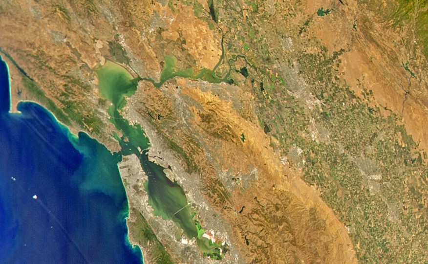
SeaHawk was able to deliver on its goal, taking pictures with ten times the resolution of SeaWiFS, a satellite-sensor used for ocean color monitoring. In the image below, the greener areas indicate higher concentrations of phytoplankton. Unlike NASA ocean color satellites, the land does not wash out and shows its true color.

IMAGE: An ocean color image of the Bay Area taken by SeaHawk. Credit: NASA
After proving that the CubeSat could provide this accurate data, the team was then able to demonstrate that it could capture images of the same areas on consecutive days, compared to more traditional tools that could only take images every couple of days. A satellite of this size has the advantage of taking high-resolution observations at a far greater frequency compared to traditional satellites and monitoring systems. SeaHawk could also point to specific areas it wanted to image as it orbited, giving it more flexibility to capture images at unique angles.
Publicly available data and collaboration
It also provided free, publicly available data, filling a valuable niche in the broader scientific community. The team’s most recent Nature article dives deep into the available resources and quality control information to help future studies of aquatic ecology and environmental change. The collaboration with NASA allowed for a first-of-a-kind partnership to integrate SeaHawk’s ocean color data with NASA’s existing datasets and infrastructure supporting ocean color satellites. NASA managed the download, collection, archiving, and distribution of all mission data, which can be accessed via the NASA Ocean Biology Distributed Active Archive Center.
Legacy and future potential
"This highly successful project didn't just pioneer low-cost satellites equipped with state-of-the-art scientific instruments – it sparked a paradigm shift," said Gary Greenburg, program officer at the Moore Foundation. "By demonstrating that CubeSats can produce high-quality scientific data, the project is transforming how scientific observation of Earth from space will be conducted in the future, opening new horizons for monitoring our planet."
After years of orbiting Earth 15 times a day at 17,000 mph, SeaHawk is being decommissioned after a failure of one of its reaction wheels, and is expected to burn up in the atmosphere in 2030. Despite that, its legacy is cemented through the thousands of images it captured, and SeaHawk serves as proof of concept that nanosatellites can be high effective at a fraction of the cost compared to traditional NASA ocean observing satellite instruments such as the Sea-viewing Wide Field-of-view Sensor (SeaWiFS), the Moderate Resolution Imaging Spectroradiometer (MODIS), or the Visible Infrared Imaging Radiometer Suite (VIIRS).
Its size and reduced cost through the use of off-the-shelf components lends itself well to replication along with rapid adaptation and improvements in further iterations of nanosatellites, offering exciting potential for further innovation in the field as scientists build off SeaHawk’s success. “My hope is that some space agency or some entrepreneur will see an advantage in this and design a constellation of instruments,” said Feldman. “By doing this as an operational mission and showing how it can seamlessly fit into an existing science program, it could evolve into something else down the road."

Message sent
Thank you for sharing.